The Rice Lake exploration properties, totaling over 61,647 hectares, cover the most prospective portions of the Rice Lake greenstone belt, part of the same belt of greenstones that includes the world-class, high-grade Red Lake gold district, located approximately 100 kilometres to the east in Ontario.
The Rice Lake belt is bound to the north along much of its length by the crustal-scale Wanipigow Fault, which also extends to Red Lake and is considered to represent a first-order control on gold mineralization, comparable in scale to the Porcupine-Destor Fault in the world-class Timmins-Porcupine Gold Camp.
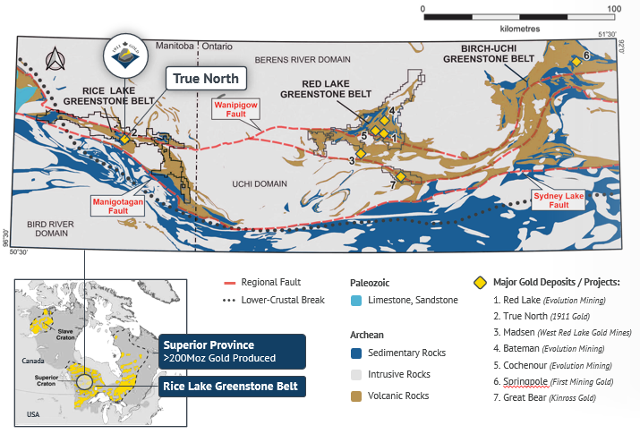
Although the Rice Lake belt has been explored for gold since the original discovery at Rice Lake in 1911, previous efforts at systematic belt-scale exploration were hindered by a highly fragmented land position. In this regard, the Company’s consolidated land position – the largest ever assembled in the belt – represents an unprecedented opportunity to evaluate this under-explored district at belt-scale, utilizing modern exploration methods.
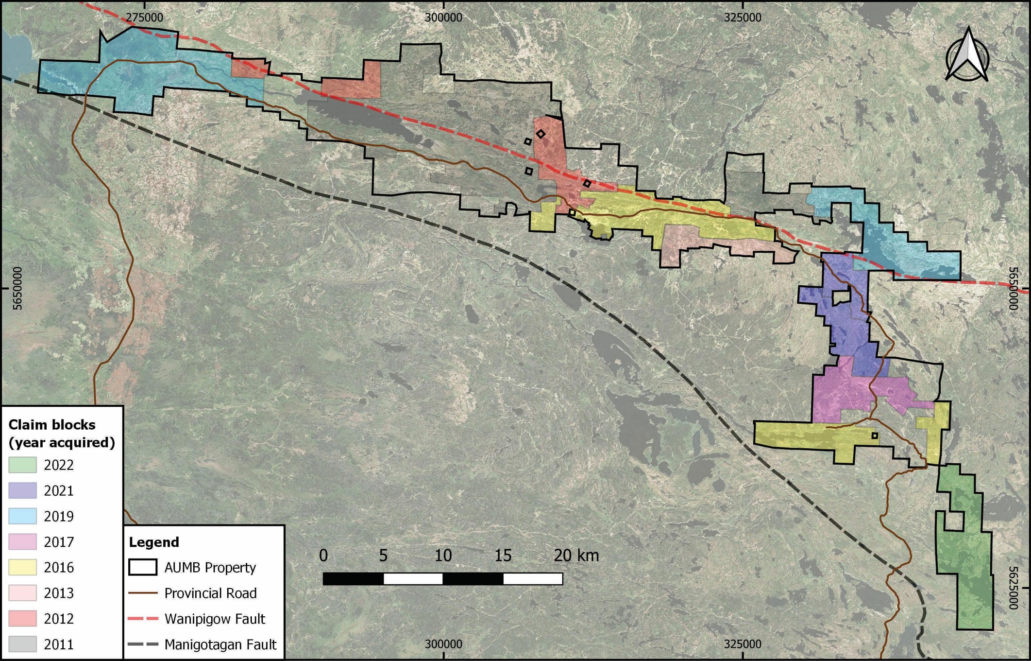
The consolidation of the Rice Lake district took place in stages between 2011 and 2017 through acquisitions by precursor companies, culminating in 2019 with the acquisition through ground staking of an additional 11,382 hectares of highly-prospective ground over the western and northeast portions of the Rice Lake greenstone belt, adjacent to the Wanipigow Fault.
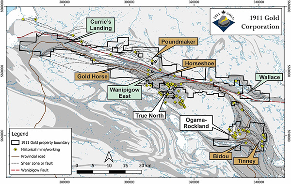
The Rice Lake exploration properties include two large, highly-prospective, claim blocks referred to as Rice Lake and Central Manitoba, each 100% owned by the Company, and both including significant past-producing mines.
The Rice Lake property consists of a continuous block of mining claims and mineral leases totaling 43,895 hectares in the western and north-central portions of the belt. It extends for approximately 80 kilometres along the Wanipigow Fault and includes the True North mine – the most significant past-producer in the Rice Lake belt, with 2 million ounces of gold production.
The Central Manitoba property, totaling 9,227 hectares, covers the prospective eastern portion of the Rice Lake belt approximately 25 kilometres southeast of the True North Complex. The geological setting is analogous to True North and includes the historic Central Manitoba, Gunnar and Ogama-Rockland mines, which account for approximately 300,000 ounces of past gold production.
The Rice Lake exploration properties, located approximately 150 kilometres northeast of the city of Winnipeg, are easily accessed year-round via provincial road 304 and 314, which service the communities of Manigotagan and Bissett, providing ready access for cost-effective exploration.
As described below, the Rice Lake greenstone belt has a number of favourable attributes indicative of its excellent prospectivity for gold deposits typical of world-class Archean gold camps, including Timmins-Porcupine, Ontario and Kalgoorlie, Western Australia.
Regional context
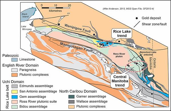
The Rice Lake greenstone belt is situated in the western Superior Province of the Canadian Shield. This Archean craton is subdivided into generally east-west trending geological domains that are bounded by sinuous faults and defined by differences in the composition, age, structure and metamorphic grade of their constituent rocks. From north to south in the Rice Lake region of Manitoba, three geological domains are defined, including the North Caribou, Uchi and English River domains, with the Rice Lake belt defining the Uchi domain.
The key geological components of each domain have different ages: 3.01–2.85 Ga in the North Caribou domain, 2.75–2.72 Ga in the Uchi domain and 2.71–2.65 Ga in the English River domain, thus becoming progressively younger to the south. Coupled with other attributes, this age distribution is most readily explained by northward tectonic accretion along an ancient plate margin – much like the western margin of the North American continent today. Importantly, this type of plate margin is the critical geodynamic setting for world-class ‘orogenic’ gold deposits.
Domain boundaries in such geodynamic settings are marked by long-lived, crustal-scale faults. In Manitoba, the Uchi domain is bound by the Wanipigow Fault on the north and the Manigotagan Fault on the south, both of which extend well over 200 kilometres along strike and are thus comparable in scale to the principal faults in other orogenic gold districts, such as the Porcupine-Destor Fault in Ontario.
Internally, the Rice Lake belt includes mafic and felsic volcanic rocks, synvolcanic mafic sills and associated sedimentary rocks, all intruded by synvolcanic felsic plutons, constituting the Bidou (2.75–2.73 Ga) and Gem (2.73–2.72 Ga) assemblages, and the Ross River plutonic suite (2.73–2.72 Ga). These units are overlain by marine and fluvial sedimentary rocks of the Edmunds (2.71–2.69 Ga) and San Antonio (<2.71 Ga) assemblages, respectively. Fluvial sedimentary rocks define fault-bounded basins along the Wanipigow Fault, whereas marine sedimentary rocks are more widespread; both are interleaved with older assemblages along early thrust faults.
North of the Wanipigow Fault, the North Caribou Domain includes the 2.99–2.92 Ga Wallace assemblage, composed of submarine tholeiitic basalt and komatiite flows and iron formations, representing a correlative to the Balmer assemblage, which hosts the most prolific deposits of the Red Lake Gold Camp.
Structures in the Rice Lake belt record a complex history of deformation, involving synvolcanic faulting, syn-sedimentary extension, early imbrication of assemblages along thrust faults, regional compression (NE-SW shortening during peak metamorphism), and culminating in regional transcurrent shear (NW-SE shortening). Major deposits in the Rice Lake belt occur along structures formed during regional NE-SW shortening, which are the principal targets for gold exploration.
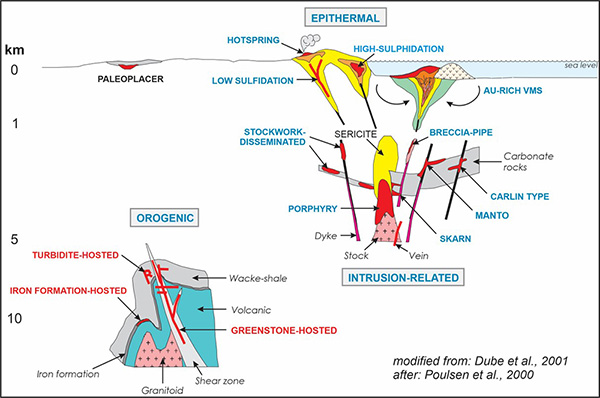
Combined, these geological attributes of the Rice Lake belt define a structural architecture that is highly prospective for orogenic gold deposits, globally significant examples of which are found along zones of enhanced structural preparation and focused hydrothermal fluid-flow, proximal to long-lived crustal-scale faults that formed during regional deformation and metamorphism within accretionary orogens.
Geology of gold mineralization
The Rice Lake greenstone belt hosts a number of significant gold deposits and hundreds of gold occurrences. The largest deposits define two trends on the opposite margins of the 2.73 Ga Ross River pluton, which occupies the central portion of the belt. Northwest of the pluton, the Rice Lake trend includes the True North, Hinge and 007 deposits with cumulative gold production of 2 million ounces, whereas the Central Manitoba trend southeast of the pluton includes the Central Manitoba, Gunnar and Ogama-Rockland deposits with cumulative gold production of 300,000 ounces. Several smaller deposits occur elsewhere in the belt, including north of the Wanipigow Fault in the North Caribou domain (Jeep, Poundmaker, Lotus).
Larger deposits in the Rice Lake belt are hosted by gabbro sills, basalt flows and dacitic volcaniclastic rocks within layered successions of volcanic and sedimentary rocks. Gold deposits and occurrences are also found in granitoid plutons, greywacke-mudstone turbidites, iron formation, komatiite flows and fluvial sedimentary rocks, highlighting both the diversity of host rocks as well as the prospectivity of the belt.
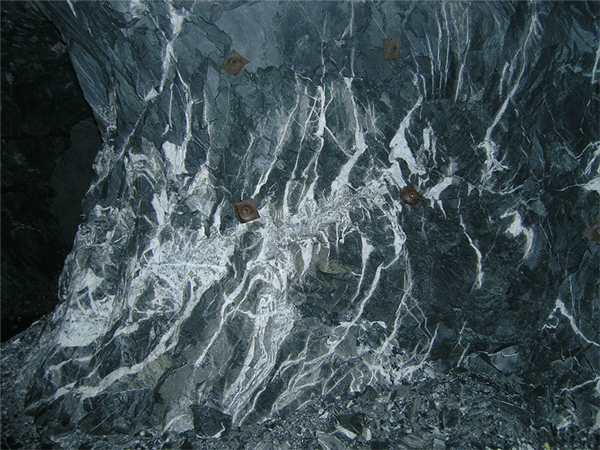
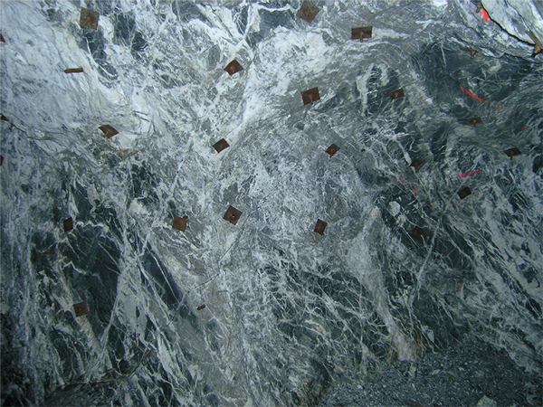
Gold in these deposits is typically hosted by quartz-carbonate vein systems in brittle-ductile shear zones that represent second- or third-order splays off regional-scale structures. In the Rice Lake mine trend, major orebodies comprise northeast-trending shear veins and northwest-trending stockwork-breccia veins. Thicker veins are often associated with inflections in shear zones indicating that they were emplaced during hydrothermal infilling of dilatant sites.
Coupled with the geometry of the vein arrays, vein textures also indicate emplacement under brittle-ductile rheological conditions. The geometry and kinematics of the controlling structures indicate they formed during regional NE–SW shortening deformation, providing a powerful tool to predict vein geometry as a guide to efficient exploration targeting on scales varying from local to regional.
Auriferous veins in the belt are typically composed of quartz, with lesser carbonate (ankerite>calcite), albite, chlorite, sericite, tourmaline and fuchsite. Sulphide minerals are mostly pyrite, with lesser pyrrhotite, chalcopyrite, sphalerite, galena and Au-Ag-As-Bi-Te sulphide minerals, such as petzite and tellurobismuthite. Arsenopyrite is locally associated with gold, particularly along the margins of first-order faults. Gold occurs as free grains or as minute inclusions in pyrite, in ores characterized by high Au:Ag ratios (>5:1) with low concentrations of base metals (Cu, Pb, Zn) and pathfinder elements (As, Bi, Te). Historical production grades varied from 5–15 g/t Au and included local bonanza grades associated with nuggety free gold.
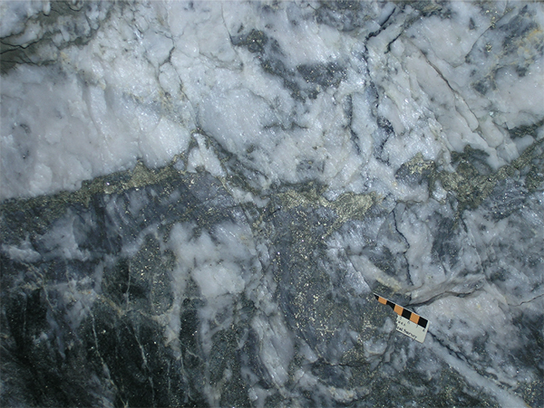
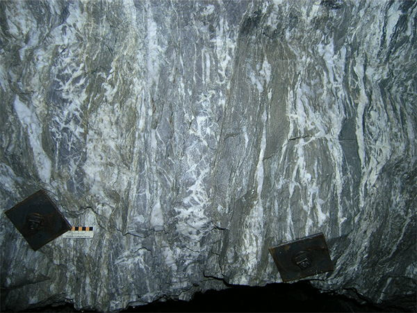
Wallrock alteration is typically zoned from proximal ankerite-sericite-pyrite or ankerite-chlorite-pyrite to distal chlorite-calcite; it varies from negligible to intense. Most veins exhibit evidence of wallrock sulphidation reactions in the form of distinct haloes of coarse pyrite. Altered and sulphidized rock with negligible vein quartz formed significant orebodies at True North, which exhibits a substantial vertical extent (>1.7 kilometres) with no variation in vein mineralogy, texture and structure.
The above characteristics identify gold deposits in the Rice Lake belt as type examples of orogenic gold deposits, also known as ‘greenstone’, ‘mesothermal’ or ‘mother lode’ deposits. The genetic model involves fluids sourced from accreted sedimentary rocks at depth during the evolution of the accretionary orogen. These fluids migrated upward along the crustal-scale faults into subsidiary structures in the mid to upper crust where gold was deposited due to physical and/or chemical changes in the ore fluid.
Overview
Previous gold exploration in the Rice Lake belt generally suffered from the fragmented land position as well as a narrow focus on historical showings, all of which were discovered through conventional surface prospecting. Areas in which the bedrock is obscured by extensive glacial cover remain virtually unexplored for gold. More recent exploration was often guided by flawed exploration models, grounded in outdated or erroneous geological theories. 1911 Gold’s exploration methodology is firmly grounded in sound geoscience.
2019 Exploration Program
In 2019, the exploration program began with the acquisition, by ground staking, of 11,382 hectares of prospective ground in underexplored portions of the Rice Lake belt, bringing the land position to 53,804 hectares and providing the Company with a dominant position along and adjacent to the Wanipigow Fault over a total strike length of 80 kilometres.
New high-resolution aeromagnetic and LiDAR data, covering roughly 21,500 and 13,400 hectares respectively, acquired over the new claim blocks was merged with leveled historical datasets to provide near-seamless coverage for the belt. Using this data, areas of favourable geology, complex fold structures and second- or third-order splays of the Wanipigow Fault have been identified in historically underexplored areas of the belt.
The Company initiated its maiden exploration program in five project areas on its 100% owned Rice Lake and Central Manitoba properties – areas identified through compilations of previous work and interpretation of aeromagnetic and LiDAR imagery in the context of the Company’s exploration model.
The Bidou and Tinny projects are located on the Central Manitoba property in the southeast portion of the Rice Lake belt. The Gold Horse, Poundmaker and Horseshoe projects are located on the Rice Lake property in the central and western portions of the belt, and are focused on subsidiary structures to the Wanipigow Fault.
The exploration methods included geological mapping, prospecting, outcrop stripping, channel sampling and structural analysis, in conjunction with rock geochemistry, surficial geochemistry (humus and black spruce bark) and ground geophysical surveys (e.g., induced potential) as appropriate. Initial reconnaissance sampling yielded high-grade gold assays from quartz-carbonate vein systems associated with brittle-ductile shear zones in four project areas, including values up to 70.4 g/t Au from the Bidou project, 114.2 g/t Au from the Tinney project, and 104.8 g/t Au from the Poundmaker project. Further details can be seen on the Company’s news release dated September 10, 2019.
Kilometre-scale targets identified by this fieldwork are characterized by anomalous gold in rocks and surficial sediments, and possess geological attributes typical of world-class gold deposits in other Archean gold districts. Each shows clear potential to yield significant gold discoveries, yet has no record of historical drilling or has been tested only by shallow localized drilling below historical showings. In 2019, four projects were advanced to drill targeting, including the Bidou, Tinney, Horseshoe and Poundmaker projects.
2019-2020 Phase 1 Exploration Drilling Program
During the Phase I exploration drilling program, completed in Q4 2019 and Q1 2020, seven targets were tested in the Bidou and Tinney project areas. The program consisted of 28 diamond drillholes (NQ), for a total of 8,086 metres, completed between November 7, 2019 and March 22, 2020, with a one-month hiatus for freeze-up. Due to unusually mild conditions, resulting in an incomplete freeze-up, the Horseshoe and Poundmaker projects could not be efficiently accessed for drilling during the Phase I program. Details of these results can be seen in the news releases dated January 30, 2020, April 30, 2020, and May 20, 2020
Tinney Project
The Tinney project area is underlain by tholeiitic basalt flows, gabbro sills and siliceous sedimentary units that are intruded by felsic porphyry intrusions and occupy the hinge of a regional-scale fold called the Beresford Lake anticline, which is partially dismembered by faults and shears. The largest felsic intrusion, the Gunnar porphyry, cuts discordantly across stratigraphy for 2.5 kilometres along strike, providing the competency contrasts and strength anisotropy necessary to facilitate structural preparation and vein emplacement; the southern extent of this porphyry hosts the historic Gunnar deposit, which produced approximately 100,000 ounces of gold between 1936 and 1941, from ore grading approximately 12 g/t Au.
During the Phase I drilling program, the Company tested three targets (Tinney Shear, Cougar and Edna-Otter) spatially associated with the Gunnar porphyry, near the hinge of the Beresford Lake anticline, which had no record of previous drilling. Shear and stockwork vein systems are developed over an area approximately 1 square kilometre in size; for comparison purposes, the footprint of the True North Gold Deposit, including the Cohiba, Hinge and 007 deposits, is roughly 1.4 square kilometres.
Tinney Shear Target
The Tinney Shear target consists of a brittle-ductile shear zone that has been traced on surface over 500 metres along strike and extends eastward from the Gunnar porphyry into the hinge of the Beresford Lake anticline. Six drill holes, totaling 1,707 metres (TS-20-001 to 006), were completed to test a 350 metre segment of this shear, yielding multiple zones of gold mineralization associated with brittle-ductile structures, quartz-carbonate vein systems and local silica-flooding.
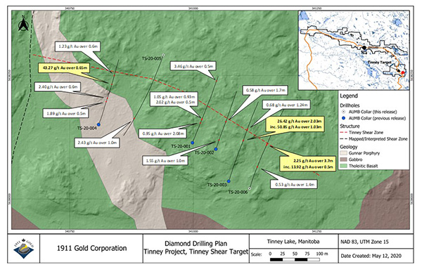
See press release dated April 30, 2020
Highlights:
Drillhole TS-20-003: intersected a shear vein with visible gold hosted by intensely sheared tholeiitic basalt, returning 26.42 g/t Au over 2.03 metres (including 50.85 g/t Au over 1.03 metres) from 157.0 to 159.03 metres downhole (see press release dated April 30, 2026).
Drillhole TS-20-004: located 290 metres along strike to the west-northwest along the same structure returned several zones of gold mineralization, highlighted by 43.27 g/t Au over 0.65 metres from 151.65 to 152.30 metres downhole hosted by a shear vein containing visible gold (see press release dated April 30, 2026).
Drillhole TS-20-006: collared 50 metres along strike to the east-southeast of TS-20-003 to test the strike continuity of the Tinney Shear, this drillhole returned 2.25 g/t Au over 3.7 metres from 160.2 to 163.9 metres downhole, including 13.92 g/t Au over 0.5 metres (from 160.9 to 161.4 metres downhole) from a laminated vein in sheared and altered (chlorite-ankerite) tholeiitic basalt. Drillhole TS-20-006 is interpreted to indicate continuity of the Tinney Shear, which remains open to the southeast towards the hinge of the Beresford Lake anticline (see press release dated May 20, 2026).
Cougar Target
The Cougar target coincides with a north-trending bend in the Gunnar porphyry thought to result from offset along a series of steeply east-dipping brittle-ductile shears, which are exposed in historical prospect pits. Two drillholes, totaling 589 metres, were completed to test these structures in the northern portion of the bend.
See press release dated April 30, 2020
Highlights (see press release dated April 30, 2020):
Drillhole CG-20-001: returned 9.29 g/t Au over 2.55 metres from 174.7 to 177.25 metres downhole, including 18.80 g/t Au over 1.05 metres, immediately adjacent to the upper and lower contacts of the Gunnar porphyry.
Drillhole CG-20-002: collared 85 metres north-northwest of CG-20-001, this drillhole returned 37.65 g/t Au over 0.5 metres from 88.15 to 88.65 metres downhole, from a laminated vein hosted by sheared basalt approximately 30 metres above the Gunnar porphyry.
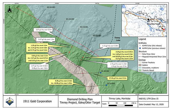
Edna-Otter Target
The Edna-Otter target coincides with the northwest extension of the Gunnar porphyry. It includes the Edna Shear, which trends roughly parallel to the porphyry for more than 500 metres along strike, as well as the Otter zone – a complex system of shear and stockwork quartz veins hosted by the porphyry. Four drillholes (EO-20-001 to 004), totaling 1,430 metres, were completed to test a 350 metre portion of this target. The most significant values were obtained from drillholes EO-20-001 and EO-20-002, which tested the southeast portion of the target adjacent to the discordant structure that constitutes the Cougar target.
Highlights (see press release dated May 20, 2020):
Drillhole EO-20-002: intersected stockwork-breccia quartz veins with visible gold hosted by the Gunnar porphyry, returning 4.29 g/t Au over 3.95 metres from 225.3 to 229.25 metres downhole (including 6.2 g/t Au over 2.55 metres from 225.3 to 227.85 metres downhole, and 28.29 g/t Au over 0.5 metres from 225.3 to 225.8 metres downhole).
Drillhole EO-20-001: located 100 metres along strike to the northwest of EO-20-002, this drillhole yielded multiple intercepts of stockwork-breccia quartz-pyrite-tourmaline veins in strongly deformed and altered Gunnar porphyry, highlighted by 1.3 g/t Au over 4.1 metres from 238.4 to 242.5 metres downhole (including 5.14 g/t Au over 0.6 metres from 238.4 to 239.0 downhole and 0.64 g/t Au over 5.6 metres from 296.7 to 302.3 metres downhole).
Given their width and grade, the structures intersected in first-pass drilling of the Edna-Otter target clearly warrant additional drilling, most notably in the untested area beneath Tinney Lake, where the Edna-Otter and Cougar structures are interpreted to intersect.
Bidou Project
The Bidou project area is underlain by basalt flows, layered gabbro sills and bedded sedimentary rocks, intruded by quartz-feldspar porphyry dikes and cut by brittle-ductile shear zones. The project area, encompassing 8 square kilometres, is adjacent to the southeast margin of the Ross River pluton – the large intrusion occupying the core of the Rice Lake belt. During the Phase I drilling program, the Company tested four targets in the Bidou project area with potential for both chemical and structural traps at a variety of scales.
Bidou Shear Target
The Company completed five drillholes, totalling 1,448 metres, to test the Bidou Shear target in locations down-dip and along strike from a historical showing. The target is located near a large-scale inflection point, thought to represent a potential site of structural dilation, in the trend of a regional-scale brittle-ductile shear zone that had not previously been tested by drilling. The shear is poorly exposed along the margins of a linear valley, which drilling revealed is underlain by sedimentary rocks, bounded on both sides by layered gabbro sills and intruded by felsic porphyry dikes.
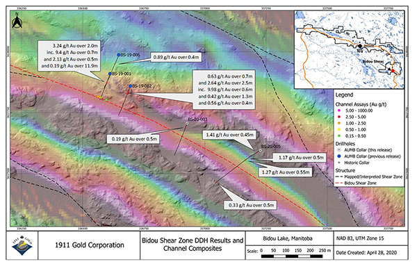
See press release dated January 30, 2020
Highlights (see press release dated January 30, 2020):
Drillhole BS-19-001: intersected a 16.2 metre interval (98.1–114.3 metres downhole) of shear and extensional quartz veins within sedimentary rocks along the contact of a gabbro sill. A shear vein with visible gold from this zone returned 9.40 g/t Au over 0.7 metres within a broader interval of 3.24 g/t Au over 2.0 metres from 98.1 to 100.2 metres downhole. This interval was followed downhole by a broad interval of scattered gold values, which returned 0.19 g/t Au over 11.9 metres (from 102.4 to 114.3 metres downhole).
Drillhole BS-19-002: designed to test the same structure in a drift-covered area 100 metres along strike to the southeast, this drillhole intersected several zones of gold mineralization associated with quartz veins and sericite-carbonate-pyrite alteration, including a laminated shear vein that yielded 2.64 g/t Au over 2.5 metres, from 81.8 to 84.3 metres downhole (including 9.98 g/t Au over 0.6 metres from 83.7 to 84.3 metres downhole).
This structure remains open along strike for several kilometres in both directions from the area of the 2019–2020 drilling and will be the focus of a follow-up exploration program.
Bidou South Target
The Company completed three drillholes, totaling 924 metres, at the Bidou South target. This target consists of a thick pyroxenite-gabbro-anorthosite sill that is cut by a series of shear zones that splay to the west-southwest off the Bidou Shear. Exposed structures exhibit intense fabric development and carbonate-sericite ±fuchsite alteration. Aeromagnetic data indicates left-lateral offsets of the sill, coinciding with topographic lineaments visible in LiDAR data. The overall scenario is analogous to the True North Gold Deposit, with potential for large-scale sites of structural dilation favourable for vein emplacement. Grab samples and surficial geochemistry indicate anomalous gold along topographic lows interpreted to delineate the main structures within a recessively-weathered segment of the sill. The drill program was designed to test this segment over a strike length of 1.5 kilometres.
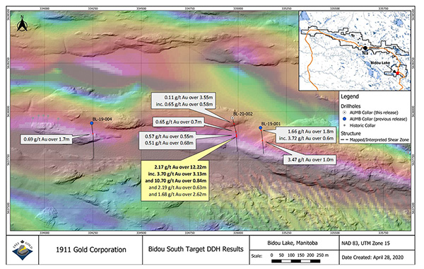
See press release dated April 30, 2020
Highlights (see press release dated January 30, 2020):
Drillhole BL-19-001: intersected shear veins and associated silica-carbonate-sericite-fuchsite-pyrite+/-arsenopyrite alteration, returning 1.66 g/t Au over 1.8 metres from 38.5 to 40.3 metres downhole (including 3.72 g/t Au over 0.6 metres), and 3.47 g/t Au over 1.0 metres from 166.8 to 167.8 metres downhole.
Drillhole BL-20-002: collared 150 metres to the west-northwest of BL-19-001, this drillhole intersected several zones of gold mineralization associated with quartz-carbonate veins, pyritized wall-rock and localized silica flooding in moderately to strongly sheared gabbro and sedimentary rocks, yielding 2.17 g/t Au over 12.22 metres from 174.0 to 186.22 metres downhole, with higher-grade intervals associated with shear veins (3.70 g/t Au over 3.13 metres from 174.0 to 177.13 metres downhole; 10.70 g/t Au over 0.84 metres from 178.23 to 179.07 metres downhole). Notable in this intercept is the intense wallrock sulphidation – a highly favourable indicator of the hydrothermal system in this location.
Midway Target
The Company completed five drillholes, totaling 1,082 metres, to test a brittle-ductile shear zone controlled by felsic porphyry dikes within tholeiitic basalt flows at the Midway target. The shear zone was tested over a strike length of approximately 550 metres and yielded a number of mineralized intercepts containing strongly anomalous to local high-grade gold values.
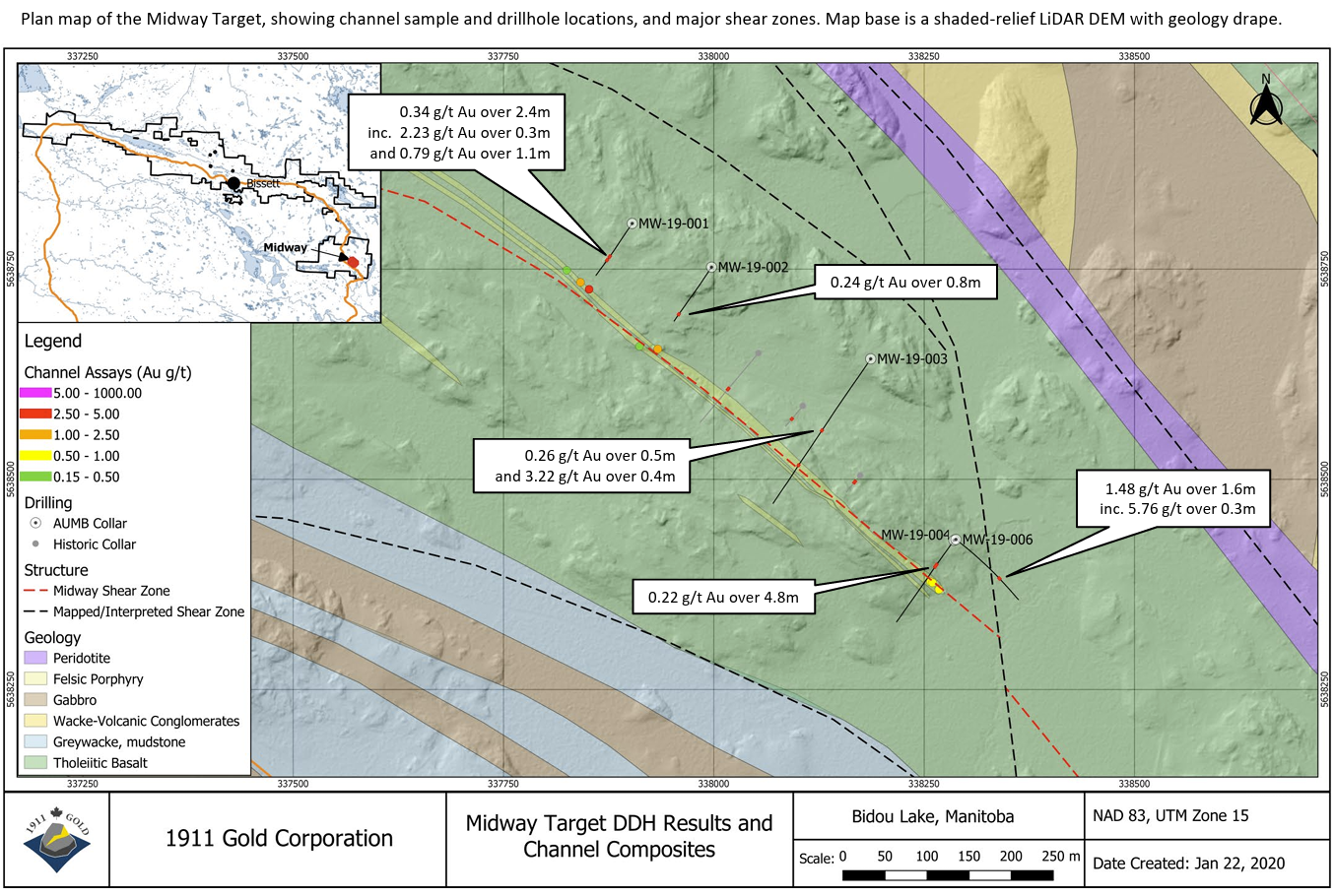
See press release dated January 30, 2020
Highlights (see press release dated January 30, 2020):
Drillhole MW-19-001: intersected silica-sericite-pyrite alteration and stockwork quartz-carbonate veins felsic porphyry, returning 0.34 g/t Au over 2.4 metres from 129.2 to 131.6 metres downhole
Drillhole MW-19-006: intersected local higher-grade intervals characterized by small-scale quartz vein stockworks, highlighted by 5.76 g/t Au over 0.3 metres from 137 to 137.3 metres downhole.
Exploration during the 2020 field season will focus on evaluating parallel structures in this area, as defined by mapping and interpretation of aeromagnetic and LiDAR data.
Janet Target
The Company completed three drillholes, totaling 906 metres, on the previously untested Janet target in the Bidou project area. The target here was a brittle-ductile shear zone that cuts at a shallow angle across tholeiitic basalt flows and interflow sedimentary rocks, intruded by a thick gabbro sill and felsic porphyry dike. The drillholes were designed to test the structure in locations where it cuts the contacts of the gabbro and porphyry intrusions. All of the drillholes intersected wide zones of shear deformation and associated alteration, with the best intercepts coming from drillholes JT-20-001 and JT-20-003, collared approximately 200 metres apart.
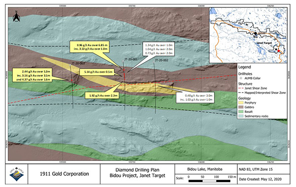
See press release dated May 20, 2020
Highlights (see press release dated May 20, 2020):
Drillhole JT-20-003: returned 2.44 g/t Au over 5.3 metres from 102.2 to 107.5 downhole associated with shear and extensional quartz-tourmaline veins.
Drillhole JT-20-001: yielded several significant intercepts, including 0.96 g/t Au over 6.85 metres from 58.0 to 64.85 metres downhole, 5.14 g/t Au over 0.5 metres from 113.0 to 113.5 metres downhole, and 1.92 g/t Au over 2.3 metres from 124.7 to 127.0 metres downhole, associated with shear and extensional quartz-tourmaline veins.
The Janet structure is interpreted to splay off the Bidou Shear approximately 1 kilometre to the west-southwest along strike, providing considerable scope for additional drilling. The movement direction and geometry of the structure indicate potential for large-scale sites of structural dilation favourable for vein emplacement.
2020 Exploration Program
In late April 2020, field crews began mobilizing to the True North site at Bissett, Manitoba, in advance of the 2020 field exploration program. This mobilization occurred in stages over several weeks, with strict adherence to comprehensive guidelines implemented to mitigate the spread of COVID-19, based on information provided by provincial public health officials.
The 2020 field exploration program is designed to continue advancing the five projects areas worked during the 2019 field season, namely the Bidou, Tinney, Gold Horse, Horseshoe and Poundmaker projects, by way of expanded bedrock mapping, prospecting and geochemical surveys (rock, humus and black-spruce bark).
These programs are designed to include reconnaissance geological mapping, prospecting and geochemical sampling. As a prelude to fieldwork in the Wanipigow East project area, the Company contracted a 2D pole-dipole DCIP (DC resistivity and induced polarization) survey to test the capability to detect and delineate sulphide mineralization beneath the thick blanket of glaciolacustrine clay that typically fills the topographic lineament along the Wanipigow Fault. The target at Wanipigow East is sulphide-associated gold mineralization hosted by sheared and folded iron formations. The survey successfully detected resistivity and chargeability features in bedrock, which will undergo 3D modeling in advance of drill targeting.
Based on the exceptional results of the Phase I exploration drilling program, the Company anticipates follow-up drilling on six of seven targets tested to date, focusing on delineating auriferous structures along strike and to depth.